RUSHUP EDGE WITH A MANTLE OF SNOW
Click on any pic to enlarge it.

On Sunday, I took a walk back in history to the first real walk I ever did in Derbyshire. It all started in 1986, when I went to Castleton on an outward bound course. Oh, I'd always been a country lad at heart, spending most weekends out on a bike ride or walking in the countryside where I lived, on the outskirts of Nottingham. We had fields within a short walk, PROPER countryside, where I watched the M1 motorway scythe through it in my teens. My claim to fame on that score is that I rode down the M1 on my bike, JUST before it was opened to traffic.
Anyway, back to the walk. As the heading suggests, it was a bit wild, to say the least. It started with rain, then went to sleet, some driving, horizontal hail, and a little light snow to finish off the day. We parked the car at Hope, and sat for a short while to see if the heavy rain would stop. It did, so we booted and suited, and set off towards Lose hill. The climb up there was in light rain. Not bad though, but as we got higher, so did the wind. By the time we got on top, it was tearing lumps out of us! Nothing loose was safe, so we tied rucksack rain covers to the sack, held on tightly to hats, and believe it or not, enjoyed it! Now, it's NO good me trying to explain this perverse enjoyment to anyone who doesn't understand it (I can't really explain it to myself), but I do get immense pleasure out of wild weather. So long as I am in my cocoon of waterproof clothes, I LOVE it! After a good while on the top at the topographic plate there, we set off along the ridge to Mam Tor, the 'shivering mountain'.
We reached the summit in no time, after meeting up with my old walking club at Hollins cross. They told us it was windy on the top, and how right they were! We had some fun, leaning into the wind and taking pictures, before dropping down to the valley. We made for a cave we knew on 'Windy knoll' (apt name today), but when we got there, found the entrance had partially collapsed the previous February, and was fenced off. We sat in a dip, the only real shelter we could find, and ate our butties. At least it wasn't raining, and the sky was a nice blue.
After that, we went down the old road beneath Mam Tor, which collapsed in the sixties. It suffered this kind of thing on a regular basis, hence the name 'shivering mountain'. The council abandoned it, and set to improving the access up Winnats Pass instead. The old road now is an incredible sight, as subsequent slips have opened up huge chasms and the steps where the road has dropped are up to six feet high!
We got into Castleton and headed for the open fire and beer in the 'Cheshire cheese' pub. We reluctantly left at about 3:45PM, and walked back to Hope in rain and, later, a lovely snow fall. The drive back was 'interesting', as some of the roads were getting quite a thick covering of snow. As is often the case, the further south, and lower, we got, the less snow there was. When I got home, the roads were dry - no rain OR snow!
This is on the nursery slopes of Lose hill. The view to the left - our goal - Mam Tor!

Here's a zoomed view of the collapsed face of Mam Tor.

The silvery thread of the upward path to Lose hill. Don't you just LOVE this kind of light? The camera tries, but as is so often the case, it isn't a patch on the eye (no pun intended!).

Win hill top peeps over the horizon as we climb. The actual hill is hidden behind that knoll.


Nearing the top, the hardest part of the walk up.

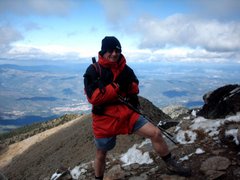
Here we go - yours truly at the top, note the smile.

The wonderful ridge walk to Mam Tor. Ah, BLISS!

This old gate post made a nice inclusion to the foreground of a picture of Kinder Scout and the snow on its Northern edge. I considered Kinder as the destination for the walk today, but 'fell back' on Mam Tor after looking at the weather reports, a prudent decision, as it happens, as mentioned above.

The rays of the sun caress Castleton. They rode across the valley like beams of a huge searchlight.

Looking back to Lose hill and Back tor.
This is a favourite view of photographers.

Here is what happens when you build a road on a geological fault! The old road was abandoned in the sixties, due to a series of landslips of the 'shivering mountain' of Mam Tor. These pictures illustrate geographically how bad this problem was (and still is).

Mountain bike, anyone?

That was it. A good day, and here I am the next morning, watching GMTV and the warnings that the Castleton road is closed because of snow!

Mountain bike, anyone?

That was it. A good day, and here I am the next morning, watching GMTV and the warnings that the Castleton road is closed because of snow!

1 comment:
Years ago, when we still lived in the UK, I remember going for a day trip to the Blue John Mine in Derbyshire. Just across from the entrance to the mine my father pointed out the Shivering Mountain - is this the same as the one here, Les ?
Lovely photos but you can keep the weather ! lol
Post a Comment