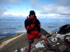
With France coming up - we decided to try a 'challenging' walk. So, I wrote one from Barber Booth, up Jacobs ladder, then along Oaken clough - losing ALL the height we just gained - and drop to the Kinder reservoir. Then, after a lunch in the warm sun, listening to the water lapping on the shore, it was another climb up to Kinder's Southern edge via the steep William clough. Once on top, I had something extra to carry - a BIG smile! It was TERRIFIC. The wind was strong, lovely and cool, but just what we needed to keep the temperature down as we laboured. The views, although a little 'blue', were stupendous. The camera has a job to capture just what we saw, I HAVE seen the odd photo that gets close, and I took one which I hope did, you be the judge. Anyway, around the edge we went, until we reached the waterfall of Kinder Downfall. I thought it might be bolder than it was, but today - it was small, almost a dribble. I've seen it in spate, and it's a sight to behold. Sometimes, when the wind is in the right direction, it blows back on itself, and looks like it will never empty. Anyway, it was still a lovely place to sit and look awhile. After this, we pressed on - along the WRONG path! My fault entirely, and I noticed after about 1/4 of a mile. Thing is, I've made this very same mistake before. You are drawn to walk around the edge, when what I SHOULD have done was head into the centre of the high moor. To cut a long story short, we decided to do a bit of bog trotting. This can be fun, very tiring, but fun. We had a lot of laughs, and eventually found out path again. You can see by the pics, Kinder is a very barren and featureless place. I have no problems up there, but you can see how people get lost! The fact is, you are never more that about 3 miles from a road, so long as you walk in a straight line! Easy, you may think, but Kinder has some magnetic rock in places, which makes the compass read wrong on occasions. This phenomenon has also been blamed for some of the many air crashes on this moor in wartime. After we found the top of Crowden clough, we set of down. It's not so much a walk here, as a scramble and small climb! No WONDER there is no marked footpath here, it's just not safe really. Again, we take this sort of thing in our stride, but when it comes towards the end of a walk, you really must take care. Tired legs can let you down, some people have been known to fall into streams, that sort of thing ;-)
The day ended with stunning evening light, and a nice, low, warm sun. What better than a pint in the Nags Head, Edale, to round off a perfect day.
Cheers!
After a slightly grey start, this is what greeted me on my way to Barber Booth car park.
This is Winnats pass, with a lovely blue sky.
And here is your April fool - wearing SHORTS!
(They mocked, but I had the last laugh on a very warm day, the right decision).
Our destination awaits, irresistible!

The wide path up to Jacobs ladder, as you can imagine from this picture, a very popular path.

The path gets steep, but lots of people come to climb it.

This is Edale cross, a famous saxon landmark.

This is Oaken clough. The big hill centre left is Mount Famine. I haven't done that one, but it's on the short list.

This little packhorse bridge could easily be missed, but what a gem!
I always want to know what people do for a living to be able to afford to live in places like this.

This is Booth sheepwash. The Peak district has many of these, one other notable one is at Ashford in the Water.
I have a picture of the explanatory plaque, if anyone wants it, ask me and I'll email it to you.

This was the view up to Kinder from the lunch stop.
Not bad, eh? Kinder downfall is in that central nick.
My attempt at the blue view we got.
Kinder res', from near to Kinder downfall.
In the troughs and grykes of Kinder high moor.
Would YOU be able to find your way through this little lot?
Even when you climb out of the troughs, there's not much to see for navigational purposes.
Our goal, and the way down to the pub :-)
Ha - looks EASY, doesn't it?
....come and have a go if you think your hard enough.......HAHAHAHAHAHAHAH!
Looking back after the hard bit - all steady downhill from here on.
Lots of pretty little waterfalls on the way down, the water is cool, but VERY brackish and unpleasant to drink.
Still a lifesaver though, if you were desperate.

Almost back at start level now, and Kinder smiles at us in the evening light
After this, it was a short 1/2 hour to the car, then five minutes to the pub.
Watch out, Mount Famine, your card's marked!
 This is Cressbrook. It's only a small hamlet, but has a very nicely restored mill which is in the dip
 Looking down to Ravenstor cottages. This view is usually only seen by climbers.


 A view across to Litton village.
 A zoomed view of Litton, with the wall patterns.
 Mum and baby resting by a wall.
 Looking back up Cressbrook dale. We walked alongside that wall on the top left.

 Nice light and shadow on the walls.
 Looking back across the buttresses we walked over.


 The usual tree.
 A pretty green lane on Longstone moor.
 We could see Mam Tor too, I've never noticed it before, but the face is unmistakable.
 The black sheep of the family.
 And that was it, apart from a coffee in Little Longstone to finish off the day.